
Photos From the Road: Lone Pine Cemeteries
Our summer road trip took us to a number of interesting places! I've previously written for Classic Movie Hub about Western movie locations we visited in Keeler, California, and around Moab, Utah. Here at this blog I've also shared our visit to Marie Windsor's gravesite in Marysvale, Utah.

It's always nice to spend time in Lone Pine separate from October's Lone Pine Film Festival, as it gives us the opportunity to do some exploring there isn't time for during the fest.
One of the things we did during our summer trip was visit Lone Pine's historic cemeteries. It may be a small town, but Lone Pine has four different cemeteries: The Depot Cemetery, Pioneer Cemetery, Mt. Whitney Cemetery, and the mass grave for victims of the 1872 Lone Pine Earthquake. All four cemeteries are managed by the Mt. Whitney Cemetery District.

As I wrote after our visit to Lone Pine in the winter of 2021, the earthquake gravesite seems to be inaccessible to the public. 16 of the 27 people killed by the quake are buried at that site. Here is a photo we took from a distance during the winter of 2021; click to enlarge it for a better view of the American flag marking the site. (October 2022 Update: Photos From the Road: Lone Pine Earthquake Cemetery.)

A closer view from a different angle on this summer's trip:

Although unable to visit that gravesite, we did visit a fascinating remnant of the earthquake which we'd never seen on all our previous visits. To find it, visit the alley behind this store, which is on the left of Main Street (Highway 395) as you travel north.

Carefully fenced off behind the store is an adobe wall. It's what remains of the Lone Pine general store which was built in 1869 -- which in turn is all that remains of Lone Pine as it existed before the earthquake struck on March 26, 1872. Modern estimates (guesstimates?) place the earthquake's strength anywhere between 7.4 and 8.3.

I've seen photos online for a historic site marker at the wall, which was dedicated in 2000, but there was nothing visible during our visit. Despite having visited Lone Pine many times over the years, this was my first time to see this interesting historic relic.

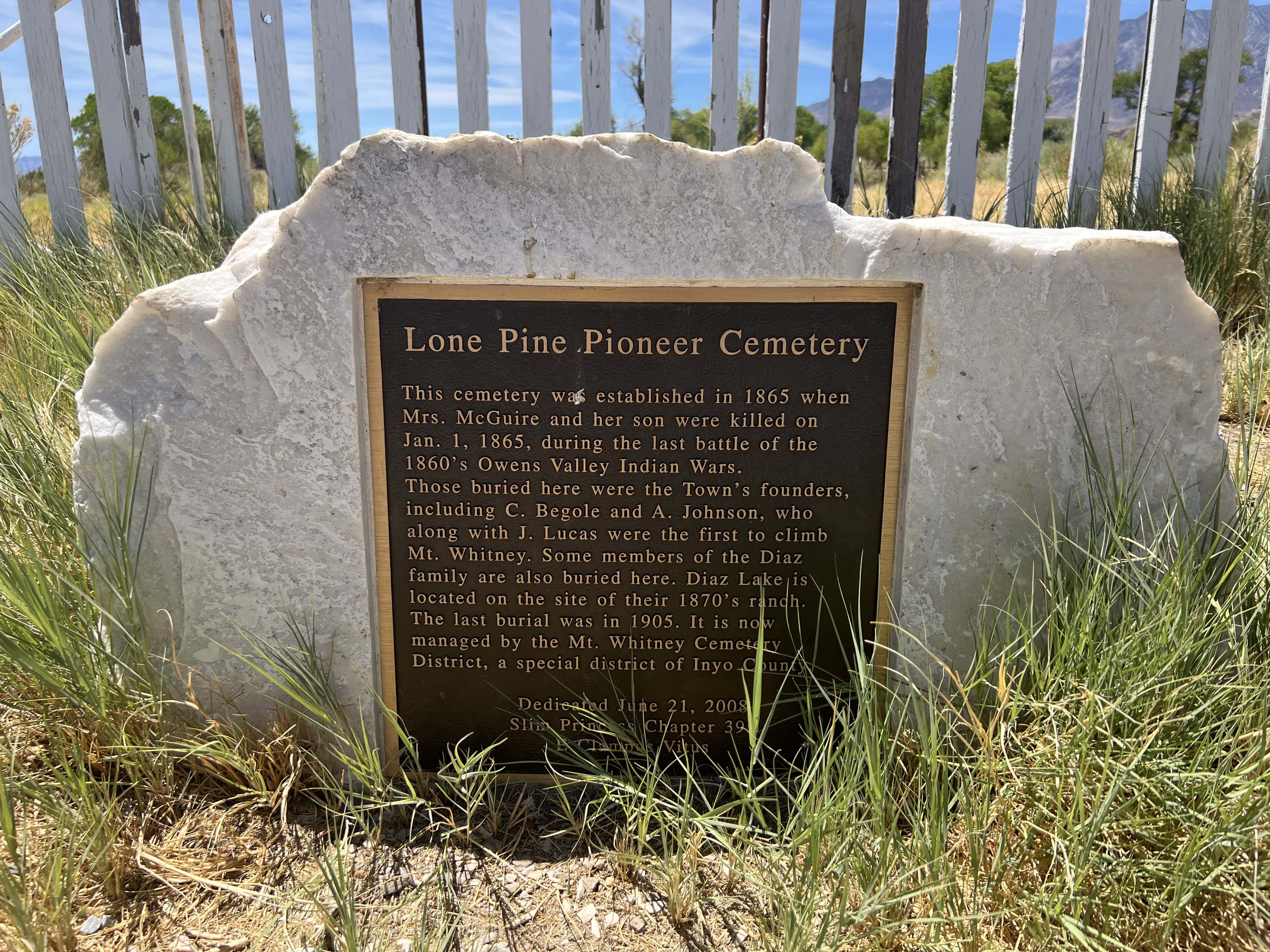
Pioneer Cemetery is the oldest cemetery in Lone Pine. According to this historical marker, the cemetery began in January 1865 with the burials of a mother and son who were killed during the last battle of the Owens Valley Indian Wars. Visiting a site such as this has a way of making "history" very real.


.JPG)
One of the notable people buried in Mt. Whitney Cemetery is Gustave Marsh, who designed and engineered the trail to the peak of Mt. Whitney in 1904.

The marker below is for the Lubken family plot; the Lubken name is prominent in Lone Pine thanks to Lubken Ranch and Lubken Canyon Road.

Thanks to visiting these cemeteries I learned a considerable amount of information about Lone Pine's history and founders.
More photo posts are planned, including a look at Southern California's Red Rock Canyon, a visit to Bryce Canyon National Park, and more.
October 2022 Update: Photos From the Road: Lone Pine Earthquake Cemetery.
Tweet
posted by Laura @ 9:40 AM
![]()
![]()
5 Comments:
I'm not sure if something has changed, but the earthquake cemetery used to be accessible. I've been there several times. You park right below it on the highway, walk up the path, and there's an entrance into the cemetery at the top. Next time you're going through there, try that. You may not have realized that you just park right there off the highway, cuz there are no real signs or anything.
Love the pics of all of these.
Thanks, Deb, we'll definitely double-check on that next month! We tried various approaches but everywhere we went we ran into barbed wire. But we were looking from the sides and the road on the far side of it from the highway; we didn't try parking on the highway shoulder, so it's possible we missed the entrance! Really appreciate that info.
Glad you enjoyed the post and hope you're doing well!
Best wishes,
Laura
Yeah, if you were on the opposite side of the highway, you might not see it, as it's just a narrow opening in the wire. The dirt path takes you right from the side of the highway right on up to the opening. Now, it's also possible they've locked the place down since the last time I was there, but it was surrounded by wire at that time too. You'll have to just walk on up and see! Definitely let me know what you find. :-D
Hi Deb, Commenting from Lone Pine in October 2022 to let you know you were right!! Wow, they sure don’t give much room to park LOL. We parked on the shoulder and spotted the opening in the wire and some man made steps. Got up to the monument and gravesite with no problem. Thank you so much for solving this mystery! I hope to share some photos soon.
Best wishes,
Laura
Oh good! I'm glad you were able to get to the monument this time. Hope the festival is going well! I'm looking forward to pictures and the report when you're home!
Post a Comment
<< Home